Showing posts with label Ramparts. Show all posts

Thursday, April 9, 2015

A Ramble over Roughting Linn...

Roughting Linn is the largest inscribed rock in Northumberland, measuring 20x12 metres and standing around 3 metres taller than the surrounding terrain. It's clear that this natural sandstone rock outcrop would have been quite the landmark in the area even before ancient artists began to decorate it. Situated only metres away from the ramparts of an Iron Age fort and at most a mile from the Goatscrag Rock Shelter by Roughting Linn Farm, it's clear this area has been of some importance for thousands of years. Even today, in its current state (which we'll talk a bit more about later) there is a special atmosphere here. The site and farm take their name from a picturesque waterfall where the Broomridgedean Burn falls over a ledge into a pool surrounded by cliffs; Linn meaning 'pool', and Roughting meaning 'bellowing noise'.


Tucked away in a little wood near Ford, Northumbria, beside an unassuming single lane road, these petroglyphs are over 4000 years old, hailing from the Neolithic/Early Bronze Age. The outcrop sports an array of cupmarks, ringmarks (some with well-defined grooves), linked grooves, radiating lines, inverted curves, maze-like carvings and keyhole-type motifs across its entire visible surface. It's possible in some areas to see that some markings have become partially covered by grass and moss. The western part of the outcrop has been lost to quarrying pre-1950, as has a section large section across the width of the site. Distribution-wise, the simpler motifs seem to be confined to the upper surface of the outcrop, while more prominent and complex designs are located on the steeper flanks. These seem to form a frieze around the edges of the rock, which would have resembled a cairn with a decorated kerb. Kerbs circling burial mounds are known at barrow sites all over Europe.


The defensive ramparts of an Iron Age promontory fort are clearly visible only metres west of the rock art panel. Several concentric deep ditches surround the site of the fort which is now intersected by the road running up to Roughting Linn Farm. On the other side of this enclosure,  access to Roughting Linn waterfall is down a rather steep escarpment, but well worth the climb.


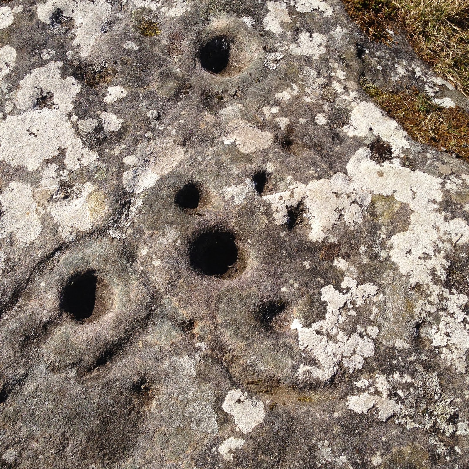
Many attempts have been made to interpret meaning behind cup- and ringmarked stones such as those at Roughting Linn. Fertility, first fruits, disease curing, animism, weather control, associations to 'little people' (elves/fairies), ringing sounds and astronomy have all been forwarded as explanations are various sites across the UK, Europe, and indeed the entire planet.


In North Yorkshire a marked stone is named the 'Fertility Stone' but the origins of the name are long lost, while the 'Tree of Life' Stone in the same area has been the site of may Day services even in recent times. Indeed many sites, especially in more remote areas, seem to be important to folklore. Offerings of milk to 'the little folk' on the islands of western Scotland are not long passed, and women in Sweden, desperate to conceive have been known to leave gifts at cupmarked stones.At the now destroyed 'Witch's Stone' at Ratho, near Edinburgh, a set of cupmarks were hewn into a boulder whose sides were smoothed by people sliding down the surface (a practice known from other sites in the area). It is believed that this was part of a superstitious fertility ritual where women wishing to bear children slid down the rockface.


Through my study of the Native American storytelling tradition way back in my Am. Lit. days, I learned that oral tradition could conserve stories over centuries and even millennia. At Roughting Linn we see the use of this same area through several ages, from the Neolithic/Bronze Age carvings, the Iron Age fort, even to the farm today right by the Goatscrag overhang. It's easy to imagine the folklore of this site being passed down through generations of people who fluctuated in and out of the area. When trying to understand why the folklore of sites around the UK may not be as well-preserved, a tragic realisation is that the persecution of 'Wise women' as witches would have left the stories and legends either dead with their storytellers or locked away in the minds of women too terrified to admit their knowledge. So, perhaps we will never know the exact meaning of cup- and ringmarked sites, but by examining the remnants of local folklore and anthropological analogies from other sites around the world, we can still make an educated guess.


What is clear is that, even to this day and despite the lack of conclusive interpretations,sites such as Roughting Linn carry a significant meaning. The atmosphere of the site was that of a sacred place, given the placement in the landscape, the cryptic art and the sounds of the waterfall cascading into the pool below. Indeed, one visitor recorded on their website having arrived to 'find the site occupied by two delightful ladies of a most spiritual nature quietly enjoying this sense of place'.

As I mentioned earlier, the site's current state demands commentary. We only found it because we saw a rock outcrop through the trees just past the road leading to Roughting Linn Farm and stopped 'just in case'. The rotting, decrepit sign I've seen on older pictures was no longer standing. The path to the site is overgrown with rhododendrons-- In fact, the entire area is overgrown and the fences (also visible on old photos of the site) are now reduced to stubs, clearly having been sawed down. Moss, grass and lichen are reclaiming the outcrop itself, and the rock art is constantly exposed to hundreds of feet trampling over it every year.

 
The saddest thing about this state of disrepair, is that there were lots of people visiting while we were there. Two large family groups and a few couples all passed through the area at the same time as my parents and I. All of them were speculating on the nature of the site; How old it was; What the symbols meant; What the ditches were. Of course, I could have babbled to them for a good few minutes and told them what I know, but wouldn't it be much better if the site were given a long overdue overhaul?


The wealth of this site is surely worth an investment. It wouldn't take too much. Put up a signpost. Clear some trees. Remove some moss and lichen. Add a few info boards explaining the site to visitors. Put up a new fence so kids don't jump around on the petrogylphs, scuffing at the porous sandstone with their trainers (because that's what they do). Point out what those ditches nearby actually are. Set up a little 'walk' around the area and include the waterfall. Make it an attraction, both for the locals and visitors to the area. It'd work a treat. The interest is there already; now it's time someone put in the effort.


Wednesday, March 18, 2015

Don't disturb the water..

Aerial view, thanks to Google maps.

On the way up past Cauldshiels Loch, you pass remnants of my family history; the spot where my brother slipped on a root and fell, and the tree where he carved his name way back in the 1980's. It's a nostalgic area, if anything. I still remember the shiver of terror that sped down my spine as I, at the age of maybe 8, paddled through the shallows-- and my brothers told me there were huge pike in the loch that would eat my toes.


The Iron Ghost!


Today, the culprit likely to rise from the loch and get me  was the Iron Ghost. My brother John has a thing about ghosts-- the Grey Man and the White Lady are also figments he's implanted in my imagination through the years. I suppose the funniest part of all this was that when I got home and began researching the nearby hill fort (aka what this post is REALLY about), the first thing that popped up was a local legend. Apparently the Loch is the lair of a mythical creature! Different sources name it as either a Kelpie or a Water Bull. Here, a visitor of Sir Walter Scott, our areas most famous of inhabitants, recounts the stories he heard of Cauldshiels Loch;


"The most interesting circumstance connected with it, however, according to Scott, was that it was haunted by a bogle in the shape of a water bull, which lived in the deep parts, and now and then came forth upon dry land and made a tremendous roaring, that shook the very hills. This story had ben current in the vicinity from time immemorial:- there was a man living who declared he had seen the bull, - and he was believed by many of his simple neighbours."
(Washington Irving, 'Abbotford and Newstead Abbey', 1835)

For those of you who don't know what a Kelpie is and who can't be bothered to read that whole wiki-article I linked to up there, here's my version of what a Kelpie is (that's the fun thing about folklore; everywhere you go, you hear slightly different tales abotu what a creature is/looks like/can do).  A Kelpie, unlike a Water Bull, can do more than roar really loudly - A Kelpie is something to beware of-- They're shapeshifters. They live in deep water or by pools along streams and can be seen as smallish men, sitting guard over their hoard of pearls. That's right, pearls. But take my advice; don't try for those pearls unless you want to find yourself in peril!
Looking up to the Fort from the Loch.


That scrawny little man, you see, can transform to a majestic, black stallion in the blink of an eye and surge out of the pool/loch to drag you under water to a horrible, wet death.....Cue evil laughter.

But yes, I digress-- we're getting very far off topic.


Cauldshiels Hillfort lies atop Cauldshiels Hill, just south of the loch. Rising 1076 feet above sea level, the fort is surrounded by a set of ramparts, plainly visible to the untrained eye. What's rather interesting about these ramparts is that they're not 'only' earthworks, aka piles of dirt moved around to make a ditch-- they're actually hewn into the bedrock! This might not be unusual for forts of this period, in fact the roundhouse foundations on the nearby Eildon Hill Fort are also mined into the bedrock, but it's still food for thought.


Panorama of the South side ramparts.

Ramparts curving around the knoll.

Living on hilltops is an excellent notion, defensively speaking. 

The defences are comprised of a continuous inner rampart circling the natural crest of the summit knoll, with the addition of a second and third rampart on the southern half of the perimeter. The two additional ramparts are each fronted by a ditch and may also have been continuous features, but there is now no trace of them along the steep northern slope.


Archaeology dog Rory, inspecting the ramparts.
Two surviving segments of the inner rampart point towards this being a drystone wall while the outer ramparts (some 5 ft high externally) were most probably constructed of heaped upcast from their respective ditches. Surface quarrying has made secure interpretation of the various rampart segments difficult. It could be that the defences are not all of one period; thus the stone rampart could represent the primary fort, while the earthen ramparts could have been added at a later date. Excavation on the defences has revealed a ditch dramatically cut into the rock and a complex sequence of entrance structures. The entrance was on the eastern side, though the gap in the inner rampart has been largely destroyed by quarrying, and the corresponding gap in one of the outer ramparts has been blocked by a later linear earthwork.

Ramparts bring out a toothy grin.
The enclosure within the inner rampart measures 220ft from east to west 120ft transversely. Geophysical survey in advance of the 1991 excavations confirmed the suspicion that there was little soil build-up above the natural bedrock. During excavation, the structural remains presented as features cut into the bedrock, and at least one circular hut was identified. Finds from this occupation consisted only of stone artefacts; whetstones and fragments of saddle quern, suggesting a date in the Iron Age.


Oh my Gosh! The Iron Ghost followed me!!

Looking around from the summit, at least 4 other hill forts are visible; Eildon Hill, the Black Hill, the Rink, and that one near Lindean Loch I can't remember the name of...

I was on a school day trip to Woden Law Hill Fort way back when I was at primary school and I remember being told that the people of these forts, spatially distributed within sight of each other, would use pieces of glass and the sun to communicate with each other. Standing atop Cauldshiels Hill Fort, it's easy to see how practical that would be:


View towards the Eildons.


'What's that you say, Woden Law? English raiders tearing up the valley towards me? Thanks mate. We'll kick their backsides back across the Border. Tell Black Hill we've got it covered.'


Not that there was a border back then. Or England. Or Scotland. You get the point.


View towards Lindean.

Now, as I did my research to write this post, I came across some info that really got my geek-bone tingling. I found a reference to a newspaper article in the Scotsman in 1991 describing a bronze burial beaker found on Cauldshiels Hill during excavations. I don't know about you, but if there's something I like more than a good Neanderthal artefact or a piece of bone fresh from a tar pit, it's a burial-- from any era. The rites performed around death have always fascinated my morbid mind.


Circle of grasstufts-- possible postholes?
Unfortunately, I have been unable to locate more information relating to this enticing burial. I've been to the local library, the Trimontium Exhibit in Melrose, written to the author, written to the newspaper and in a last ditch effort, I've even written to the Trimontium Trust in hopes that they'll be able to locate a copy-- and if they can, I'll expand upon the burial.

Clearly, the Scottish Borders needs to put a lot of work into public accessibility... No one's going to care about the past if the information isn't readily available-- there's more to the Borders than Sir Walter Scott.


---

WANTED
HAVE YOU SEEN THIS ARTICLE?
Jones, R {F J} {et al.} (1991b) 'The Newstead project', Univ Bradford Archaeol Sci Annu Rep 5th annual report
Page(s): 15

IF FOUND PLEASE MAIL TO ARCHAEOAMOS@GMAIL.COM

---